- Home
- Councils
- District councils
- Wychavon
District councilCurrentE07000238
Wychavon District Council
Local authority area: Wychavon
Wychavon is a district council in Worcestershire, in the West Midlands region of England. It covers 663.5 km² and had 134,536 residents in 2022 — about 203 people per km². The council is based in Pershore.
Town hall in the administrative centrePershore Civic Centre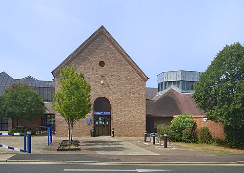
Photo: Des Blenkinsopp · CC BY-SA 2.0 · Wikimedia Commons
People
Population
Estimates recorded for Wychavon, 2011–2022.
Residents, 2022134,536+14.9% since 2011
Land area663.5km²256.2 sq mi
Density203/ km²people per square kilometre
Rank by population#232of 382 UK councils · #197 in England
Population estimates6 data points
117.1K117.7K121.5K127.3K132.5K134.5K
201120122015201820212022
Same county
All councils in West MidlandsOther councils in Worcestershire
Elections
27 electoral wards
Census 2021: 132,490 residents in 57,352 households across the wards; 24.9% aged 65+, 70.1% of homes owned, 11.8% of households without a car.
1Pershore3,970 households · 29.4% aged 65+8,4012North Claines & Salwarpe3,116 households · 21.8% aged 65+7,6443Evesham South3,191 households · 22.8% aged 65+7,4054Hampton3,116 households · 18.3% aged 65+7,2305Droitwich South East2,696 households · 20.3% aged 65+6,7546Drakes Broughton, Norton & Whittington2,719 households · 18.4% aged 65+6,705
Visit
Council offices
Offices, town halls and local council offices in the area.
TEvesham Town HallTown hall · Evesham WR11 4RL · hours listedPBroadway Parish Council incuding Neighbourhood PlanParish council · Broadway WR12 7AP · hours listed
Westminster
Constituencies
Source: Wikidata Q2116344 (CC0)Figures as recorded with their reference year; boundaries may have changed since.