- Home
- Councils
- County councils
- Suffolk
County councilCurrentE10000029
Suffolk County Council
Local authority area: Suffolk
Suffolk is a county council, in the East of England region of England. It covers 3,800.9 km² and had 768,555 residents in 2022 — about 202 people per km². The council is based in Ipswich.
Council headquartersEast Suffolk County Hall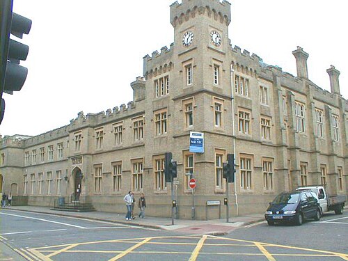
Photo: michael wade · CC BY-SA 2.0 · Wikimedia Commons
People
Population
Estimates recorded for Suffolk, 2012–2022.
Residents, 2022768,555+5.0% since 2012
Land area3,800.9km²1,467.6 sq mi
Density202/ km²people per square kilometre
Rank by population#16of 382 UK councils · #16 in England
Population estimates4 data points
732.3K741.9K758.6K768.6K
2012201520182022
Borders
Neighbouring councils
Same region, same type
All councils in East of EnglandOther county councils in East of England
Elections
63 county electoral divisions
Divisions are built from district wards (ONS best-fit lookup); residents are the Census 2021 totals of those wards.
| Division | District | Wards | Residents |
|---|---|---|---|
| Aldeburgh and Leiston | East Suffolk | 1 | 11,741 |
| Beccles | East Suffolk | 1 | 14,591 |
| Belstead Brook | Babergh | 3 | 11,583 |
| Bixley | Ipswich | 1 | 7,446 |
| Blackbourn | West Suffolk | 4 | 10,555 |
| Blything | East Suffolk | 6 | 36,573 |
| Bosmere | Mid Suffolk | 5 | 21,474 |
| Brandon | West Suffolk | 4 | 18,869 |
| Bridge | Ipswich | 2 | 20,533 |
| Bungay | East Suffolk | 2 | 18,332 |
| Carlford | East Suffolk | 2 | 17,267 |
| Chantry | Ipswich | 3 | 23,452 |
| Clare | West Suffolk | 4 | 16,450 |
| Cosford | Babergh | 4 | 13,465 |
| Eastgate and Moreton Hall | West Suffolk | 2 | 10,240 |
| Exning and Newmarket | West Suffolk | 3 | 13,407 |
| Felixstowe Coastal | East Suffolk | 2 | 24,328 |
| Felixstowe North and Trimley | East Suffolk | 3 | 34,781 |
| Framlingham | East Suffolk | 3 | 17,817 |
| Gainsborough | Ipswich | 2 | 16,967 |
| Gipping Valley | Mid Suffolk | 3 | 12,068 |
| Great Cornard | Babergh | 1 | 9,950 |
| Gunton | East Suffolk | 3 | 29,140 |
| Hadleigh | Babergh | 2 | 8,755 |
| Halesworth | East Suffolk | 2 | 12,278 |
| Hardwick | West Suffolk | 2 | 9,280 |
| Hartismere | Mid Suffolk | 4 | 12,156 |
| Haverhill Cangle | West Suffolk | 4 | 20,079 |
| Haverhill East and Kedington | West Suffolk | 4 | 19,039 |
| Hoxne and Eye | Mid Suffolk | 4 | 11,453 |
| Kesgrave and Rushmere St. Andrew | East Suffolk | 3 | 27,651 |
| Kessingland and Southwold | East Suffolk | 4 | 21,962 |
| Lowestoft South | East Suffolk | 3 | 36,898 |
| Martlesham | East Suffolk | 2 | 17,226 |
| Melford | Babergh | 2 | 12,191 |
| Mildenhall | West Suffolk | 5 | 19,566 |
| Newmarket and Red Lodge | West Suffolk | 6 | 25,517 |
| Oulton | East Suffolk | 3 | 26,128 |
| Pakefield | East Suffolk | 3 | 33,685 |
| Peninsula | Babergh | 4 | 10,778 |
| Priory Heath | Ipswich | 1 | 9,651 |
| Row Heath | West Suffolk | 5 | 27,098 |
| Rushmere | Ipswich | 2 | 18,182 |
| Samford | Babergh | 4 | 12,214 |
| St. Helen's | Ipswich | 2 | 18,812 |
| St. John's | Ipswich | 2 | 20,392 |
| St. Margaret's and Westgate | Ipswich | 3 | 26,019 |
| Stour Valley | Babergh | 4 | 11,052 |
| Stowmarket North and Stowupland | Mid Suffolk | 5 | 27,693 |
| Stowmarket South | Mid Suffolk | 3 | 15,682 |
| Sudbury | Babergh | 4 | 13,617 |
| Sudbury East and Waldingfield | Babergh | 5 | 19,562 |
| Thedwastre North | Mid Suffolk | 4 | 18,333 |
| Thedwastre South | Mid Suffolk | 5 | 25,201 |
| Thingoe North | West Suffolk | 3 | 10,149 |
| Thingoe South | West Suffolk | 6 | 20,393 |
| Thredling | Mid Suffolk | 7 | 26,649 |
| Tower | West Suffolk | 5 | 26,976 |
| Upper Gipping | Mid Suffolk | 8 | 30,336 |
| Whitehouse and Whitton | Ipswich | 3 | 24,822 |
| Wickham | East Suffolk | 4 | 23,242 |
| Wilford | East Suffolk | 5 | 32,191 |
| Woodbridge | East Suffolk | 1 | 7,881 |
Visit
Council offices
Offices, town halls and local council offices in the area.
Source: Wikidata Q23111 (CC0)Figures as recorded with their reference year; boundaries may have changed since.