- Home
- Councils
- County councils
- Norfolk
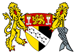
County councilCurrentE10000020
Norfolk County Council
Local authority area: Norfolk
Norfolk is a county council, in the East of England region of England. It covers 5,380.0 km² and had 925,299 residents in 2022 — about 172 people per km². The council is based in Norwich.
Town hall in the administrative centreCity Hall, Norwich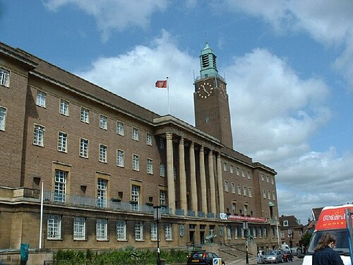
Photo: GaryReggae · CC BY-SA 2.0 · Wikimedia Commons
People
Population
Estimates recorded for Norfolk, 1086–2022.
Residents, 2022925,299+524.8% since 1086
Land area5,380.0km²2,077.2 sq mi
Density172/ km²people per square kilometre
Rank by population#8of 382 UK councils · #8 in England
Population estimates10 data points
148.1K486.9K176.8K251.4K273.5K561.1K865.3K903.7K914K925.3K
1086129013771761180119612012201820202022
Borders
Neighbouring councils
Abroad
Twinned with
Norfolk
Same region, same type
All councils in East of EnglandOther county councils in East of England
Elections
84 county electoral divisions
Divisions are built from district wards (ONS best-fit lookup); residents are the Census 2021 totals of those wards.
| Division | District | Wards | Residents |
|---|---|---|---|
| Acle | Broadland | 3 | 8,719 |
| Attleborough | Breckland | 2 | 13,070 |
| Aylsham | Broadland | 2 | 11,622 |
| Blofield and Brundall | Broadland | 2 | 12,568 |
| Bowthorpe | Norwich | 2 | 24,724 |
| Breydon | Great Yarmouth | 3 | 19,797 |
| Caister-on-Sea | Great Yarmouth | 2 | 8,803 |
| Catton Grove | Norwich | 2 | 22,379 |
| Clavering | South Norfolk | 5 | 24,855 |
| Clenchwarton and King's Lynn South | King's Lynn and West Norfolk | 5 | 21,176 |
| Costessey | South Norfolk | 2 | 16,676 |
| Crome | Norwich | 1 | 11,991 |
| Cromer | North Norfolk | 3 | 10,360 |
| Dereham North | Breckland | 3 | 19,121 |
| Dereham South | Breckland | 3 | 19,259 |
| Dersingham | King's Lynn and West Norfolk | 4 | 17,761 |
| Diss and Roydon | South Norfolk | 1 | 10,921 |
| Docking | King's Lynn and West Norfolk | 4 | 13,362 |
| Downham Market | King's Lynn and West Norfolk | 4 | 11,349 |
| Drayton and Horsford | Broadland | 3 | 11,093 |
| East Depwade | South Norfolk | 2 | 12,659 |
| East Flegg | Great Yarmouth | 2 | 9,683 |
| Eaton | Norwich | 1 | 10,118 |
| Elmham and Mattishall | Breckland | 3 | 17,587 |
| Fakenham | North Norfolk | 3 | 10,749 |
| Feltwell | King's Lynn and West Norfolk | 4 | 14,410 |
| Fincham | King's Lynn and West Norfolk | 7 | 31,570 |
| Forehoe | South Norfolk | 3 | 18,728 |
| Freebridge Lynn | King's Lynn and West Norfolk | 2 | 12,747 |
| Gayton and Nar Valley | King's Lynn and West Norfolk | 4 | 19,958 |
| Gaywood North and Central | King's Lynn and West Norfolk | 3 | 14,888 |
| Gaywood South | King's Lynn and West Norfolk | 6 | 29,733 |
| Gorleston St. Andrews | Great Yarmouth | 2 | 10,167 |
| Guiltcross | Breckland | 5 | 20,605 |
| Hellesdon | Broadland | 2 | 11,122 |
| Henstead | South Norfolk | 3 | 20,866 |
| Hevingham and Spixworth | Broadland | 3 | 10,918 |
| Hingham | South Norfolk | 3 | 8,997 |
| Holt | North Norfolk | 6 | 19,477 |
| Hoveton and Stalham | North Norfolk | 3 | 14,215 |
| Humbleyard | South Norfolk | 2 | 14,170 |
| King's Lynn North and Central | King's Lynn and West Norfolk | 3 | 14,893 |
| Lakenham | Norwich | 1 | 10,685 |
| Loddon | South Norfolk | 5 | 22,187 |
| Long Stratton | South Norfolk | 4 | 14,160 |
| Lothingland | Great Yarmouth | 2 | 13,315 |
| Magdalen | Great Yarmouth | 2 | 15,150 |
| Mancroft | Norwich | 4 | 44,471 |
| Marshland North | King's Lynn and West Norfolk | 3 | 14,908 |
| Marshland South | King's Lynn and West Norfolk | 4 | 22,803 |
| Melton Constable | North Norfolk | 7 | 17,610 |
| Mile Cross | Norwich | 1 | 11,202 |
| Mundesley | North Norfolk | 5 | 13,109 |
| Necton and Launditch | Breckland | 5 | 20,103 |
| Nelson | Norwich | 1 | 10,435 |
| North Coast | King's Lynn and West Norfolk | 4 | 11,439 |
| North Walsham East | North Norfolk | 6 | 23,111 |
| North Walsham West and Erpingham | North Norfolk | 5 | 16,657 |
| Old Catton | Broadland | 1 | 8,496 |
| Reepham | Broadland | 3 | 8,649 |
| Sewell | Norwich | 1 | 10,352 |
| Sheringham | North Norfolk | 3 | 9,838 |
| South Smallburgh | North Norfolk | 5 | 18,399 |
| Sprowston | Broadland | 2 | 14,875 |
| Swaffham | Breckland | 3 | 14,041 |
| Taverham | Broadland | 2 | 9,837 |
| The Brecks | Breckland | 6 | 22,248 |
| Thetford East | Breckland | 3 | 19,042 |
| Thetford West | Breckland | 3 | 19,074 |
| Thorpe Hamlet | Norwich | 4 | 42,981 |
| Thorpe St. Andrew | Broadland | 2 | 10,762 |
| Town Close | Norwich | 2 | 20,317 |
| University | Norwich | 1 | 14,551 |
| Watton | Breckland | 3 | 22,102 |
| Wells | North Norfolk | 6 | 16,628 |
| Wensum | Norwich | 3 | 37,720 |
| West Depwade | South Norfolk | 5 | 25,643 |
| West Flegg | Great Yarmouth | 2 | 8,014 |
| Woodside | Broadland | 2 | 16,895 |
| Wroxham | Broadland | 4 | 20,054 |
| Wymondham | South Norfolk | 3 | 18,281 |
| Yare and All Saints | Breckland | 4 | 24,488 |
| Yarmouth Nelson and Southtown | Great Yarmouth | 2 | 15,029 |
| Yarmouth North and Central | Great Yarmouth | 2 | 13,107 |
Source: Wikidata Q23109 (CC0)Figures as recorded with their reference year; boundaries may have changed since.