- Home
- Councils
- District councils
- High Peak
District councilCurrentE07000037
High Peak Borough Council
Local authority area: High Peak
High Peak is a district council in Derbyshire, in the East Midlands region of England. It covers 539.1 km² and had 91,109 residents in 2022 — about 169 people per km². The authority dates from 1974. The council is based in Buxton.
Town hall in the administrative centreBuxton Town Hall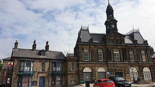
Photo: Douglal · CC BY-SA 4.0 · Wikimedia Commons
People
Population
Estimates recorded for High Peak, 2012–2022.
Residents, 202291,109+0.0% since 2012
Land area539.1km²208.2 sq mi
Density169/ km²people per square kilometre
Rank by population#337of 382 UK councils · #283 in England
Population estimates4 data points
91.1K91.5K92.2K91.1K
2012201520182022
History
How the council came to be
- 1974Created
High Peak became a local authority area.
Borders
Neighbouring councils
Elections
28 electoral wards
Census 2021: 90,934 residents in 40,771 households across the wards; 21.8% aged 65+, 71.0% of homes owned, 16.9% of households without a car.
1Whaley Bridge2,849 households · 23.5% aged 65+6,3172Chapel West2,191 households · 24.1% aged 65+4,9613Howard Town2,383 households · 18.3% aged 65+4,6824Blackbrook1,952 households · 24.0% aged 65+4,5965Old Glossop1,917 households · 20.4% aged 65+4,5196Stone Bench1,842 households · 14.9% aged 65+4,471
Visit
Council offices
Offices, town halls and local council offices in the area.
CHigh Peak Borough CouncilCouncil office · High Peak SK23 7SWCHigh Peak Borough CouncilCouncil office · Buxton SK17 6EL · hours listedTGlossop Town HallTown hall · Glossop SK13 8AF · hours listed
Westminster
Constituencies
Source: Wikidata Q1458060 (CC0)Figures as recorded with their reference year; boundaries may have changed since.