- Home
- Councils
- County councils
- Derbyshire

County councilCurrentE10000007
Derbyshire County Council
Local authority area: Derbyshire
Derbyshire is a county council, in the East Midlands region of England. It covers 2,546.8 km² and had 803,464 residents in 2022 — about 315 people per km².
Council headquartersCounty Hall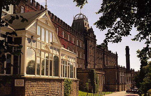
Photo: Dave Bevis · CC BY-SA 2.0 · Wikimedia Commons
People
Population
Estimates recorded for Derbyshire, 2012–2022.
Residents, 2022803,464+3.9% since 2012
Land area2,546.8km²983.3 sq mi
Density315/ km²people per square kilometre
Rank by population#14of 382 UK councils · #14 in England
Population estimates3 data points
773.5K796.1K803.5K
201220182022
Same region, same type
All councils in East MidlandsOther county councils in East Midlands
Elections
64 county electoral divisions
Divisions are built from district wards (ONS best-fit lookup); residents are the Census 2021 totals of those wards.
| Division | District | Wards | Residents |
|---|---|---|---|
| Alfreton & Somercotes | Amber Valley | 2 | 15,000 |
| Alport & Duffield | Amber Valley | 2 | 11,699 |
| Ashbourne South | Derbyshire Dales | 4 | 13,997 |
| Aston | South Derbyshire | 3 | 20,676 |
| Bakewell | Derbyshire Dales | 5 | 14,849 |
| Barlborough & Clowne | Bolsover | 4 | 15,858 |
| Bolsover | Bolsover | 4 | 18,478 |
| Breadsall & West Hallam | Erewash | 2 | 10,566 |
| Breaston | Erewash | 3 | 15,650 |
| Brimington | Chesterfield | 3 | 16,311 |
| Buxton North & East | High Peak | 4 | 13,809 |
| Buxton South & West | High Peak | 4 | 11,942 |
| Chapel & Hope Valley | High Peak | 4 | 12,895 |
| Clay Cross & Tupton | North East Derbyshire | 3 | 16,059 |
| Codnor, Aldercar, Langley Mill & Loscoe | Amber Valley | 2 | 19,195 |
| Derwent Valley | Derbyshire Dales | 6 | 22,521 |
| Dovedale & Ashbourne North | Derbyshire Dales | 6 | 20,864 |
| Dronfield & Unstone | North East Derbyshire | 4 | 17,270 |
| Dronfield Woodhouse & Walton | North East Derbyshire | 5 | 17,769 |
| Dunston | Chesterfield | 2 | 13,758 |
| Eckington & Coal Aston | North East Derbyshire | 4 | 15,601 |
| Elmton with Creswell & Whitwell | Bolsover | 3 | 15,325 |
| Etherow | High Peak | 5 | 13,395 |
| Etwall & Findern | South Derbyshire | 2 | 14,400 |
| Glossop North | High Peak | 5 | 15,705 |
| Glossop South | High Peak | 4 | 13,012 |
| Hardwick | Bolsover | 4 | 19,794 |
| Hasland & Rother | Chesterfield | 2 | 15,572 |
| Heanor | Amber Valley | 2 | 17,139 |
| Hilton | South Derbyshire | 2 | 12,557 |
| Horsley | Amber Valley | 2 | 14,355 |
| Ilkeston Central | Erewash | 3 | 18,495 |
| Ilkeston North | Erewash | 3 | 15,023 |
| Ilkeston South & Kirk Hallam | Erewash | 2 | 11,459 |
| Killamarsh & Renishaw | North East Derbyshire | 3 | 15,418 |
| Linacre & Loundsley Green | Chesterfield | 2 | 11,366 |
| Linton | South Derbyshire | 3 | 19,533 |
| Long Eaton North | Erewash | 2 | 12,382 |
| Long Eaton South | Erewash | 2 | 12,230 |
| Matlock | Derbyshire Dales | 2 | 11,155 |
| Melbourne & Woodville | South Derbyshire | 3 | 20,529 |
| New Mills & Hayfield | High Peak | 4 | 12,071 |
| North Belper | Amber Valley | 2 | 15,886 |
| North Wingfield, Pilsley & Morton | North East Derbyshire | 3 | 17,433 |
| Repton & Stenson | South Derbyshire | 3 | 18,444 |
| Ripley East | Amber Valley | 2 | 16,217 |
| Ripley West & Crich | Amber Valley | 3 | 15,319 |
| Sandiacre | Erewash | 4 | 25,904 |
| Sawley | Erewash | 2 | 14,033 |
| Shirebrook & Pleasley | Bolsover | 4 | 20,721 |
| Shirland & Wingerworth South | North East Derbyshire | 5 | 25,172 |
| South Belper & Holbrook | Amber Valley | 3 | 22,779 |
| South Normanton & Pinxton | Bolsover | 3 | 15,792 |
| Spire | Chesterfield | 2 | 13,108 |
| Staveley | Chesterfield | 2 | 14,026 |
| Staveley North & Whittington | Chesterfield | 2 | 13,152 |
| Sutton | North East Derbyshire | 4 | 18,343 |
| Swadlincote East | South Derbyshire | 3 | 26,189 |
| Swadlincote South | South Derbyshire | 3 | 23,534 |
| Swadlincote West | South Derbyshire | 3 | 25,108 |
| Swanwick & Riddings | Amber Valley | 3 | 17,433 |
| Walton, Brampton & Boythorpe | Chesterfield | 3 | 18,751 |
| Whaley Bridge | High Peak | 2 | 10,913 |
| Wirksworth | Derbyshire Dales | 5 | 15,439 |
Visit
Council offices
Offices, town halls and local council offices in the area.
Source: Wikidata Q11775003 (CC0)Figures as recorded with their reference year; boundaries may have changed since.