- Home
- Councils
- County councils
- Lincolnshire
County councilCurrentE10000019
Lincolnshire County Council
Local authority area: Lincolnshire
Lincolnshire is a county council, in the East Midlands region of England. It covers 5,937.3 km² and had 775,524 residents in 2022 — about 131 people per km².
Council headquartersCounty Offices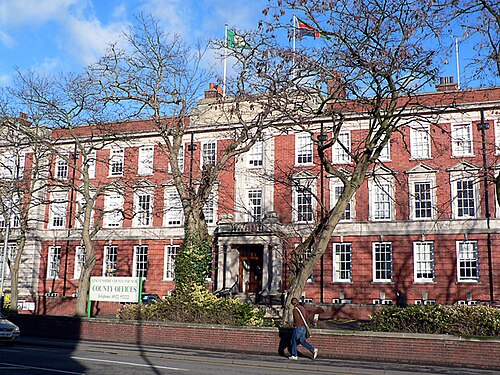
Photo: Ian Carrington · CC BY-SA 2.0 · Wikimedia Commons
People
Population
Estimates recorded for Lincolnshire, 2012–2022.
Residents, 2022775,524+7.9% since 2012
Land area5,937.3km²2,292.4 sq mi
Density131/ km²people per square kilometre
Rank by population#15of 382 UK councils · #15 in England
Population estimates3 data points
718.8K755.8K775.5K
201220182022
Same region, same type
All councils in East MidlandsOther county councils in East Midlands
Elections
70 county electoral divisions
Divisions are built from district wards (ONS best-fit lookup); residents are the Census 2021 totals of those wards.
| Division | District | Wards | Residents |
|---|---|---|---|
| Alford & Sutton | East Lindsey | 4 | 14,097 |
| Bardney & Cherry Willingham | West Lindsey | 2 | 10,697 |
| Bassingham & Welbourn | North Kesteven | 4 | 19,607 |
| Birchwood | Lincoln | 2 | 17,136 |
| Boston Coastal | Boston | 3 | 14,716 |
| Boston North | Boston | 3 | 15,018 |
| Boston Rural | Boston | 3 | 15,758 |
| Boston South | Boston | 3 | 14,973 |
| Boston West | Boston | 5 | 22,572 |
| Boultham | Lincoln | 3 | 31,306 |
| Bourne North and Morton | South Kesteven | 3 | 12,462 |
| Bourne South and Thurlby | South Kesteven | 4 | 17,614 |
| Carholme | Lincoln | 2 | 18,952 |
| Colsterworth Rural | South Kesteven | 5 | 16,823 |
| Crowland | South Holland | 5 | 23,607 |
| Deepings East | South Kesteven | 3 | 20,079 |
| Deepings West and Rural | South Kesteven | 3 | 15,267 |
| Donington Rural | South Holland | 2 | 14,818 |
| Eagle & Hykeham West | North Kesteven | 4 | 23,139 |
| Ermine & Cathedral | Lincoln | 2 | 15,979 |
| Folkingham Rural | South Kesteven | 5 | 12,462 |
| Gainsborough Hill | West Lindsey | 2 | 15,073 |
| Gainsborough Rural South | West Lindsey | 4 | 10,225 |
| Gainsborough Trent | West Lindsey | 2 | 13,059 |
| Grantham Barrowby | South Kesteven | 3 | 17,134 |
| Grantham East | South Kesteven | 2 | 9,553 |
| Grantham North | South Kesteven | 3 | 15,899 |
| Grantham South | South Kesteven | 2 | 13,123 |
| Grantham West | South Kesteven | 3 | 15,856 |
| Hartsholme | Lincoln | 3 | 25,182 |
| Heckington | North Kesteven | 4 | 16,294 |
| Holbeach | South Holland | 3 | 14,706 |
| Holbeach Rural | South Holland | 5 | 19,413 |
| Horncastle & the Keals | East Lindsey | 6 | 27,012 |
| Hough | South Kesteven | 3 | 12,374 |
| Hykeham Forum | North Kesteven | 2 | 14,659 |
| Ingoldmells Rural | East Lindsey | 4 | 11,713 |
| Louth North | East Lindsey | 5 | 15,529 |
| Louth South | East Lindsey | 5 | 14,044 |
| Louth Wolds | East Lindsey | 6 | 17,256 |
| Mablethorpe | East Lindsey | 3 | 12,934 |
| Market Rasen Wolds | West Lindsey | 3 | 13,612 |
| Metheringham Rural | North Kesteven | 3 | 14,445 |
| Nettleham & Saxilby | West Lindsey | 2 | 10,211 |
| North Wolds | West Lindsey | 3 | 10,930 |
| Park | Lincoln | 3 | 34,570 |
| Potterhanworth & Coleby | North Kesteven | 4 | 26,499 |
| Ruskington | North Kesteven | 2 | 10,761 |
| Saltfleet & the Cotes | East Lindsey | 5 | 14,044 |
| Scotter Rural | West Lindsey | 2 | 10,205 |
| Skegness North | East Lindsey | 3 | 21,127 |
| Skegness South | East Lindsey | 3 | 14,669 |
| Skirbeck | Boston | 3 | 20,729 |
| Sleaford | North Kesteven | 4 | 11,917 |
| Sleaford Rural | North Kesteven | 3 | 15,477 |
| Spalding East | South Holland | 3 | 17,495 |
| Spalding Elloe | South Holland | 5 | 27,335 |
| Spalding South | South Holland | 4 | 22,706 |
| Spalding West | South Holland | 3 | 19,091 |
| St. Giles | Lincoln | 2 | 20,029 |
| Stamford East | South Kesteven | 3 | 14,979 |
| Stamford West | South Kesteven | 3 | 15,514 |
| Swallow Beck & Witham | Lincoln | 2 | 16,182 |
| Tattershall Castle | East Lindsey | 2 | 14,591 |
| The Suttons | South Holland | 2 | 12,150 |
| Waddington & Hykeham East | North Kesteven | 3 | 23,386 |
| Wainfleet | East Lindsey | 6 | 18,404 |
| Washingborough | North Kesteven | 2 | 12,880 |
| Welton Rural | West Lindsey | 2 | 11,416 |
| Woodhall Spa & Wragby | East Lindsey | 6 | 22,058 |
Visit
Council offices
Offices, town halls and local council offices in the area.
Source: Wikidata Q21269047 (CC0)Figures as recorded with their reference year; boundaries may have changed since.