- Home
- Councils
- County councils
- Hampshire
County councilCurrentE10000014
Hampshire County Council
Local authority area: Hampshire
Hampshire is a county council, in the South East England region of England. It covers 3,678.9 km² and had 1,416,808 residents in 2022 — about 385 people per km².
Council headquartersCastle Hill Offices County Hall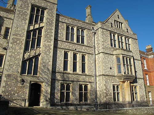
Photo: Mike Quinn · CC BY-SA 2.0 · Wikimedia Commons
People
Population
Estimates recorded for Hampshire, 2012–2022.
Residents, 20221,416,808+6.5% since 2012
Land area3,678.9km²1,420.4 sq mi
Density385/ km²people per square kilometre
Rank by population#3of 382 UK councils · #3 in England
Population estimates3 data points
1.3M1.4M1.4M
201220182022
Same region, same type
All councils in South EastOther county councils in South East
Elections
76 county electoral divisions
Divisions are built from district wards (ONS best-fit lookup); residents are the Census 2021 totals of those wards.
| Division | District | Wards | Residents |
|---|---|---|---|
| Aldershot North | Rushmoor | 3 | 23,868 |
| Aldershot South | Rushmoor | 3 | 24,155 |
| Alton Rural | East Hampshire | 5 | 26,201 |
| Alton Town | East Hampshire | 7 | 19,433 |
| Andover North | Test Valley | 4 | 28,106 |
| Andover South | Test Valley | 3 | 24,014 |
| Andover West | Test Valley | 4 | 23,511 |
| Baddesley | Test Valley | 4 | 24,003 |
| Basingstoke Central | Basingstoke and Deane | 3 | 32,150 |
| Basingstoke North | Basingstoke and Deane | 4 | 45,176 |
| Basingstoke North West | Basingstoke and Deane | 4 | 40,555 |
| Basingstoke South East | Basingstoke and Deane | 3 | 30,892 |
| Basingstoke South West | Basingstoke and Deane | 4 | 42,176 |
| Bishops Waltham | Winchester | 4 | 28,241 |
| Bishopstoke & Fair Oak | Eastleigh | 2 | 21,943 |
| Botley & Hedge End North | Eastleigh | 2 | 17,598 |
| Bridgemary | Gosport | 4 | 24,370 |
| Brockenhurst | New Forest | 6 | 32,433 |
| Calleva | Basingstoke and Deane | 5 | 50,387 |
| Candovers, Oakley & Overton | Basingstoke and Deane | 3 | 29,827 |
| Catherington | East Hampshire | 5 | 16,680 |
| Chandler's Ford | Eastleigh | 2 | 21,127 |
| Church Crookham & Ewshot | Hart | 3 | 27,514 |
| Cowplain & Hart Plain | Havant | 2 | 19,080 |
| Dibden & Hythe | New Forest | 3 | 20,179 |
| Eastleigh North | Eastleigh | 2 | 20,640 |
| Eastleigh South | Eastleigh | 3 | 33,153 |
| Emsworth & St. Faiths | Havant | 2 | 21,040 |
| Fareham Crofton | Fareham | 4 | 29,651 |
| Fareham Portchester | Fareham | 3 | 20,875 |
| Fareham Sarisbury | Fareham | 3 | 22,976 |
| Fareham Titchfield | Fareham | 5 | 35,629 |
| Fareham Town | Fareham | 6 | 41,600 |
| Fareham Warsash | Fareham | 4 | 31,071 |
| Farnborough North | Rushmoor | 4 | 29,239 |
| Farnborough South | Rushmoor | 3 | 22,486 |
| Farnborough West | Rushmoor | 3 | 21,255 |
| Fleet Town | Hart | 4 | 37,476 |
| Hamble | Eastleigh | 2 | 20,449 |
| Hardway | Gosport | 3 | 18,080 |
| Hartley Wintney & Yateley West | Hart | 4 | 35,684 |
| Hayling Island | Havant | 2 | 17,392 |
| Hedge End & West End South | Eastleigh | 3 | 27,390 |
| Itchen Valley | Winchester | 4 | 29,288 |
| Lee | Gosport | 3 | 18,515 |
| Leesland & Town | Gosport | 6 | 34,186 |
| Liphook, Headley & Grayshott | East Hampshire | 3 | 18,121 |
| Loddon | Basingstoke and Deane | 2 | 20,889 |
| Lymington & Boldre | New Forest | 3 | 19,467 |
| Lyndhurst & Fordingbridge | New Forest | 4 | 22,059 |
| Meon Valley | Winchester | 3 | 21,928 |
| New Milton | New Forest | 3 | 21,503 |
| New Milton North, Milford & Hordle | New Forest | 3 | 22,243 |
| North East Havant | Havant | 3 | 37,307 |
| North West Havant | Havant | 3 | 35,211 |
| Odiham & Hook | Hart | 2 | 18,812 |
| Petersfield Butser | East Hampshire | 6 | 23,421 |
| Petersfield Hangers | East Hampshire | 7 | 29,790 |
| Purbrook & Stakes South | Havant | 2 | 19,703 |
| Ringwood | New Forest | 3 | 22,220 |
| Romsey Rural | Test Valley | 7 | 46,351 |
| Romsey Town | Test Valley | 3 | 20,264 |
| South Waterside | New Forest | 3 | 21,260 |
| Tadley & Baughurst | Basingstoke and Deane | 3 | 31,514 |
| Test Valley Central | Test Valley | 4 | 25,549 |
| Totton North & Netley Marsh | New Forest | 4 | 33,975 |
| Totton South & Marchwood | New Forest | 3 | 23,223 |
| Waterloo & Stakes North | Havant | 4 | 39,566 |
| West End & Horton Heath | Eastleigh | 3 | 23,287 |
| Whitchurch & The Cleres | Basingstoke and Deane | 3 | 31,423 |
| Whitehill, Bordon & Lindford | East Hampshire | 4 | 18,451 |
| Winchester Downlands | Winchester | 4 | 32,396 |
| Winchester Eastgate | Winchester | 3 | 28,284 |
| Winchester Southern Parishes | Winchester | 3 | 25,620 |
| Winchester Westgate | Winchester | 4 | 34,603 |
| Yateley East & Blackwater | Hart | 3 | 25,566 |
Source: Wikidata Q21694653 (CC0)Figures as recorded with their reference year; boundaries may have changed since.