- Home
- Councils
- Metropolitan boroughs
- Rotherham

Metropolitan boroughCurrentE08000018
Rotherham Metropolitan Borough Council
Local authority area: Rotherham
Rotherham is a metropolitan borough, in the Yorkshire and the Humber region of England. It covers 286.5 km² and had 268,354 residents in 2022 — about 937 people per km². The authority dates from 1974. The council is based in Rotherham.
Town hall in the administrative centreRotherham Town Hall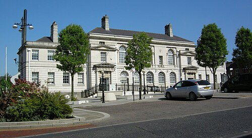
Photo: Paul Eggleston · CC BY-SA 2.0 · Wikimedia Commons
People
Population
Estimates recorded for Rotherham, 2011–2022.
Residents, 2022268,354-80.0% since 2011
Land area286.5km²110.6 sq mi
Density937/ km²people per square kilometre
Rank by population#92of 382 UK councils · #85 in England
Population estimates5 data points
1.3M258.4K260.8K264.7K268.4K
20112012201520182022
History
How the council came to be
- 1974Created
Formed from Rotherham Rural District, Kiveton Park Rural District, County Borough of Rotherham.
Same region, same type
All councils in Yorkshire and the HumberOther metropolitan boroughs in Yorkshire and the Humber
Elections
25 electoral wards
Census 2021: 265,809 residents in 113,925 households across the wards; 19.6% aged 65+, 63.6% of homes owned, 23.0% of households without a car.
1Rotherham East6,627 households · 13.4% aged 65+16,7472Boston Castle6,100 households · 15.9% aged 65+15,2373Rotherham West6,218 households · 16.5% aged 65+14,6194Keppel5,884 households · 19.5% aged 65+13,6445Hoober5,376 households · 16.1% aged 65+12,9896Wickersley North5,521 households · 19.8% aged 65+12,785
Visit
Council offices
Offices, town halls and local council offices in the area.
CRotherham CouncilCouncil office · Rotherham S60 2ERCRotherham Investment & Development Office (RiDO)Council office · Rotherham S60 1AE · hours listedCRotherham Metropolitan Borough CouncilCouncil office · Rotherham S60 1AE · hours listedTRotherham Town HallTown hall · Rotherham S60 2TH · hours listedPWickersley Parish CouncilParish council · Rotherham S66 1JJ · hours listedPWoodsetts Parish CouncilParish council · Worksop S81 8AS
Westminster
Constituencies
Source: Wikidata Q1878732 (CC0)Figures as recorded with their reference year; boundaries may have changed since.