Metropolitan boroughCurrentE08000035
Leeds City Council
Local authority area: Leeds
Leeds is a metropolitan borough, in the Yorkshire and the Humber region of England. It covers 551.7 km² and had 822,483 residents in 2022 — about 1,491 people per km². The authority dates from 1974. The council is based in Leeds.
Town hall in the administrative centreLeeds Town Hall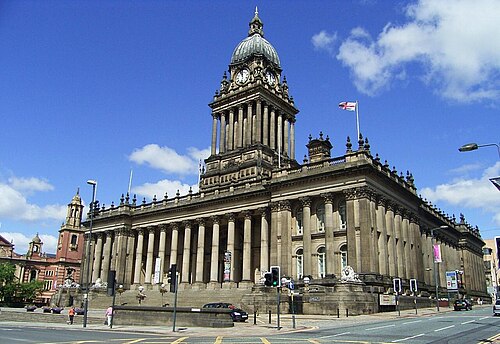
Photo: Andrew roberts uk · CC BY-SA 3.0 · Wikimedia Commons
People
Population
Estimates recorded for Leeds, 2012–2022.
Residents, 2022822,483+8.5% since 2012
Land area551.7km²213.0 sq mi
Density1,491/ km²people per square kilometre
Rank by population#13of 382 UK councils · #13 in England
Population estimates4 data points
757.7K774.1K789.2K822.5K
2012201520182022
History
How the council came to be
- 1974Created
Formed from County Borough of Leeds.
Abroad
Twinned with
BrnoColomboDortmundDurbanHangzhouLilleLouisvilleSiegenUlaanbaatar
Same region, same type
All councils in Yorkshire and the HumberOther metropolitan boroughs in Yorkshire and the Humber
Elections
33 electoral wards
Census 2021: 811,952 residents in 341,467 households across the wards; 15.6% aged 65+, 57.0% of homes owned, 28.7% of households without a car.
1Headingley & Hyde Park10,331 households · 4.3% aged 65+31,1752Little London & Woodhouse10,000 households · 2.9% aged 65+31,0763Gipton & Harehills10,704 households · 7.4% aged 65+30,8794Middleton Park12,146 households · 12.1% aged 65+29,6055Burmantofts & Richmond Hill12,377 households · 9.2% aged 65+28,5286Armley11,818 households · 10.9% aged 65+26,725
Visit
Council offices
Offices, town halls and local council offices in the area.
CArmley Community HubCouncil office · Leeds LS12 1UQ · hours listedCBramley Community HubCouncil office · Leeds LS13 3ND · hours listedCFamily Information Service LeedsCouncil office · Leeds LS2 8BB · hours listedCGarforth One Stop CentreCouncil office · Leeds LS25 1EH · hours listedCHunslet Community HubCouncil office · Leeds LS10 2NS · hours listedCKippax Community HubCouncil office · Leeds LS25 7LY · hours listedCLeeds City Centre Hub, Merrion HouseCouncil office · Leeds LS2 8LX · hours listedCMorley One Stop CentreCouncil office · Leeds LS27 9DY · hours listedTMorley Town HallTown hall · Leeds LS27 9DYTWetherby Town HallTown hall · Wetherby LS22 6NE · hours listedTLeeds City Council Parks and Countryside ServiceTown council · Leeds LS12 5HATLeeds Housing Options (Leeds City Council)Town council · Leeds LS2 8BB · hours listed
Westminster
Constituencies
Source: Wikidata Q774015 (CC0)Figures as recorded with their reference year; boundaries may have changed since.