- Home
- Councils
- Metropolitan boroughs
- South Tyneside
Metropolitan boroughCurrentE08000023
South Tyneside Council
Local authority area: South Tyneside
South Tyneside is a metropolitan borough, in the North East England region of England. It covers 64.4 km² and had 148,667 residents in 2022 — about 2,309 people per km². The authority dates from 1974. The council is based in South Shields.
Town hall in the administrative centreMunicipal Buildings, South Shields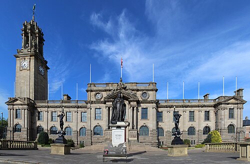
Photo: Chabe01 · CC BY-SA 4.0 · Wikimedia Commons
People
Population
Estimates recorded for South Tyneside, 2012–2022.
Residents, 2022148,667+0.2% since 2012
Land area64.4km²24.9 sq mi
Density2,309/ km²people per square kilometre
Rank by population#197of 382 UK councils · #169 in England
Population estimates4 data points
148.4K148.7K150.3K148.7K
2012201520182022
History
How the council came to be
- 1974Created
South Tyneside became a local authority area.
Abroad
Twinned with
Noisy-le-SecWuppertalÉpinay-sur-Seine
Borders
Neighbouring councils
Same region, same type
All councils in North EastOther metropolitan boroughs in North East
Elections
18 electoral wards
Census 2021: 147,772 residents in 68,283 households across the wards; 20.9% aged 65+, 56.6% of homes owned, 32.7% of households without a car.
1Hebburn South4,561 households · 18.8% aged 65+10,1862Horsley Hill & Westoe Crown4,436 households · 23.5% aged 65+9,8323Simonside & Rekendyke4,862 households · 17.7% aged 65+9,6044Primrose4,297 households · 21.0% aged 65+9,2605Boldon Colliery4,026 households · 20.8% aged 65+8,8466Hebburn North3,890 households · 14.1% aged 65+8,737
Visit
Council offices
Offices, town halls and local council offices in the area.
Source: Wikidata Q1541228 (CC0)Figures as recorded with their reference year; boundaries may have changed since.