- Home
- Councils
- District councils
- Broxtowe
District councilCurrentE07000172
Broxtowe Borough Council
Local authority area: Broxtowe
Broxtowe is a district council in Nottinghamshire, in the East Midlands region of England. It covers 80.1 km² and had 112,113 residents in 2022 — about 1,400 people per km². The authority dates from 1974. The council is based in Beeston.
Town hall in the administrative centreBeeston Town Hall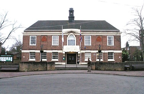
Photo: David Lally · CC BY-SA 2.0 · Wikimedia Commons
People
Population
Estimates recorded for Broxtowe, 2012–2022.
Residents, 2022112,113+1.3% since 2012
Land area80.1km²30.9 sq mi
Density1,400/ km²people per square kilometre
Rank by population#281of 382 UK councils · #236 in England
Population estimates4 data points
110.7K112.3K113.3K112.1K
2012201520182022
History
How the council came to be
- 1974Created
Broxtowe became a local authority area.
Abroad
Twinned with
Gütersloh
Same county
All councils in East MidlandsOther councils in Nottinghamshire
Elections
20 electoral wards
Census 2021: 110,301 residents in 48,025 households across the wards; 21.8% aged 65+, 71.5% of homes owned, 19.8% of households without a car.
1Toton & Chilwell Meadows3,395 households · 20.4% aged 65+8,0642Chilwell West3,357 households · 21.9% aged 65+7,5913Bramcote3,125 households · 28.7% aged 65+7,2444Attenborough & Chilwell East3,064 households · 26.7% aged 65+7,1235Kimberley3,011 households · 22.2% aged 65+6,5926Greasley2,923 households · 27.4% aged 65+6,549
Visit
Council offices
Offices, town halls and local council offices in the area.
Westminster
Constituencies
Source: Wikidata Q605605 (CC0)Figures as recorded with their reference year; boundaries may have changed since.